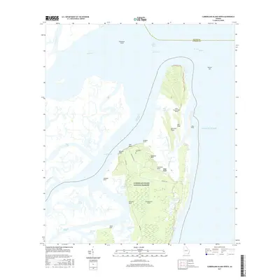
2017 Map of Cumberland Island North
USGS Topo · Published 2017About this map
Cumberland Island National Seashore dominates this coastal landscape where the Satilla River and Cumberland River meet the Atlantic Ocean. The map documents a complex estuarine environment defined by tidal marshlands and interior ridges like East Ridge and Sanctuary Ridge. On the northern end of the island, the small Cumberland Cem and the settlement at High Point represent the limited human footprint within this protected wilderness.
Find a feature on this map
41 named features on this map. Tap any name to fly to it.
Don’t see what you’re looking for? This feature index may not catch every label — zoom into the map to look around manually.
Map Details
Editions of this 2017 Cumberland Island North Map
This is the sole edition of this map. No revisions or reprints were ever made.
Other maps of this area

1918 · Cumberland Island
USGS Topo · 1:62,500

1918 · Bladen
USGS Topo · 1:62,500

1918 · Kingsland
USGS Topo · 1:62,500

1930 · Cumberland Island
USGS Topo · 1:62,500

1939 · Bladen
USGS Topo · 1:62,500

1945 · Brunswick
USGS Topo · 1:62,500

1945 · Cumberland Island
USGS Topo · 1:62,500

1946 · Brunswick
USGS Topo · 1:250,000

1948 · Jacksonville
USGS Topo · 1:250,000

1948 · Brunswick
USGS Topo · 1:250,000