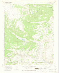
1967 Map of Cumbres
USGS Topo · Published 1975About this map
The Denver and Rio Grande Western narrow-gauge rail line winds through the high-elevation landscape of the Rio Grande National Forest in this 1967 survey. The rail route is the centerpiece of the southern map area, marked by the iconic Cumbres Pass and the Cumbres Snow Shed at the settlement of Cumbres. This area showcases a transitional mountain economy where seasonal grazing and recreation overlap, illustrated by the La Manga Cow Camp and the La Manga Summer Home Group near La Manga Pass. Water management and recreation are central to the terrain, evidenced by the Trujillo Meadows Reservoir and its adjacent Trujillo Meadows Campground. Significant elevation markers such as Jarosa Peak and Neff Mountain dominate the central topography, while the Continental Divide Trail traces a path through the western reaches of the quadrangle.
Find a feature on this map
51 named features on this map. Tap any name to fly to it.
Don’t see what you’re looking for? This feature index may not catch every label — zoom into the map to look around manually.
Map Details
Editions of this 1967 Cumbres Map
4 editions found
Other maps of this area

1913 · Summitville
USGS Topo · 1:125,000

1915 · Summitville
USGS Topo · 1:125,000

1918 · Tusas
USGS Topo · 1:125,000

1922 · Conejos
USGS Topo · 1:125,000

1945 · Durango
USGS Topo · 1:250,000

1953 · Durango
USGS Topo · 1:250,000

1954 · Durango
USGS Topo · 1:250,000

1954 · Aztec
USGS Topo · 1:250,000

1955 · Chama
USGS Topo · 1:62,500

1955 · Brazos Peak
USGS Topo · 1:62,500