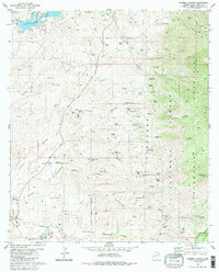
1981 Map of Cumero Canyon
USGS Topo · Published 1985About this map
Mining operations and ranching land define the landscape of the Patagonia Mountains and the drainage of Sonoita Creek during the early 1980s. This survey records a transition from water-focused recreation at Patagonia Lake State Park to the industrial history found in the canyons. The eastern slopes are dotted with numerous workings like the Three R Mine, Flux Mine, and Golden Rose Mine, while land grants like the Luis Maria Baca Float No. 3 reflect the region's complex history of colonial land claims. Aviation infrastructure is prominent with the Nogales International Airport and its Airway Beacon serving the border region. Family ranching legacies are visible through the Circle Z Ranch and T 4 Ranch, situated alongside countless cattle tanks and wells including Paja Verde Tank and Javelina Well.
Find a feature on this map
91 named features on this map. Tap any name to fly to it.
Don’t see what you’re looking for? This feature index may not catch every label — zoom into the map to look around manually.
Map Details
Editions of this 1981 Cumero Canyon Map
3 editions found
Other maps of this area

1904 · Patagonia
USGS Topo · 1:125,000

1905 · Patagonia
USGS Topo · 1:125,000

1905 · Nogales
USGS Topo · 1:125,000

1922 · Agus Caliente
USGS Topo · 1:62,500

1932 · Lochiel
USGS Topo · 1:62,500

1932 · Elgin
USGS Topo · 1:62,500

1933 · Calabasas
USGS Topo · 1:62,500

1940 · Elgin
USGS Topo · 1:62,500

1947 · Elgin
USGS Topo · 1:62,500

1948 · Harshaw
USGS Topo · 1:24,000