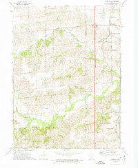
1972 Map of Cumming
USGS Topo · Published 1975About this map
The town of Cumming serves as a focal point in the northeastern corner of this 1970s landscape, where the Chicago and North Western railroad line runs north-south through the terrain. The map documents a predominantly rural section of the Iowa countryside at the intersection of Linn, Lee, Crawford, and Jefferson townships. Significant local heritage sites are concentrated near the settlements, including St Johns Ch and its namesake St Johns Cem just north of town, and Calvary Cem situated near Churchville. The topography is defined by the drainage patterns of the North River and its various tributaries, such as Badger Creek and Cherry Creek, which create a series of ridges and valleys that dictate the grid-like placement of roads like NW 82d Avenue and NW 54th Avenue.
Find a feature on this map
27 named features on this map. Tap any name to fly to it.
Don’t see what you’re looking for? This feature index may not catch every label — zoom into the map to look around manually.
Map Details
Editions of this 1972 Cumming Map
This is the sole edition of this map. No revisions or reprints were ever made.
Other maps of this area

1905 · Des Moines
USGS Topo · 1:62,500

1907 · Des Moines
USGS Topo · 1:62,500

1908 · Waukee
USGS Topo · 1:62,500

1931 · Indianola
USGS Topo · 1:62,500

1951 · St. Charles
USGS Topo · 1:62,500

1954 · Des Moines
USGS Topo · 1:250,000

1956 · Des Moines
USGS Topo · 1:250,000

1956 · Des Moines SW
USGS Topo · 1:24,000

1956 · Des Moines
USGS Topo · 1:62,500

1957 · Des Moines
USGS Topo · 1:250,000