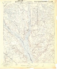
1919 Map of Cummings
USGS Topo · Published 1919About this map
The Salkehatchie River and Lumber River define this low-lying territory along the border of Colleton and Hampton counties at the end of the Great War. This landscape is remarkably dense with community infrastructure, featuring an extensive network of small schools and country churches that served as the social centers for rural families. Prominent settlements like Islandton, Bells Crossroads, and Sniders Crossroads act as hubs for the surrounding farmsteads.
Find a feature on this map
61 named features on this map. Tap any name to fly to it.
Don’t see what you’re looking for? This feature index may not catch every label — zoom into the map to look around manually.
Map Details
Editions of this 1919 Cummings Map
3 editions found
Other maps of this area

1918 · Walterboro
USGS Topo · 1:62,500

1918 · Green Pond
USGS Topo · 1:62,500

1918 · Varnville
USGS Topo · 1:62,500

1918 · Yemassee
USGS Topo · 1:62,500

1919 · Pineland
USGS Topo · 1:62,500

1919 · Olar
USGS Topo · 1:62,500

1919 · Cummings
USGS Topo · 1:62,500

1919 · Lodge
USGS Topo · 1:62,500

1920 · Lodge
USGS Topo · 1:48,000

1920 · St. George
USGS Topo · 1:48,000