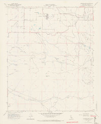
1966 Map of Cummings Mtn
USGS Topo · Published 1967About this map
The California Correctional Institution dominates the northern reaches of Cummings Valley, situated near the base of the surrounding mountains in Kern County. This mid-1960s landscape shows a transition from the agricultural valley floor to the steep drainages of Tejon Canyon and White Cow Canyon. Local infrastructure for the era includes the Cummings Valley Sch and a small Cem located near Girado Road, serving the rural population scattered along Pellisier Road and Banducci Road. The geography is defined by prominent peaks like Cummings Mtn and the network of canyons including Cedar Canyon and Live Oak Canyon. Water management is evident through the presence of Sewage Disposal Ponds, several Water Tanks, and numerous named springs such as Stag Spring and Cedar Spring, which support the high-altitude ranching and institutional needs of the region.
Find a feature on this map
43 named features on this map. Tap any name to fly to it.
Don’t see what you’re looking for? This feature index may not catch every label — zoom into the map to look around manually.
Map Details
Editions of this 1966 Cummings Mtn Map
4 editions found
Other maps of this area

1903 · Tejon
USGS Topo · 1:125,000

1914 · Caliente
USGS Topo · 1:125,000

1915 · Elizabeth Lake
USGS Topo · 1:125,000

1915 · Mojave
USGS Topo · 1:125,000

1917 · Elizabeth Lake
USGS Topo · 1:125,000

1930 · Bear Mountain
USGS Topo · 1:31,680

1933 · Bear Mountain
USGS Topo · 1:31,680

1943 · Tehachapi
USGS Topo · 1:62,500

1943 · Cummings Mountain
USGS Topo · 1:62,500

1943 · Neenach
USGS Topo · 1:62,500