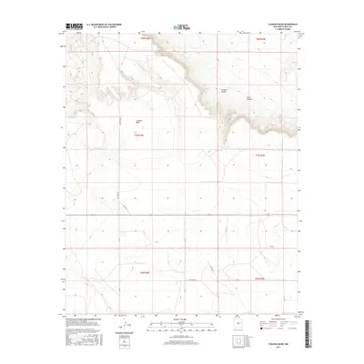
2017 Map of Cunavea Basin
USGS Topo · Published 2017About this map
Cunavea Basin defines the geographic character of this high desert landscape in Quay County, where significant topographic shifts separate the flatlands from the etched terrain of Hartford Canyon. The map reveals a remote ranching or grazing environment structured by a grid of named section lines and rural routes such as Quay Road Be and Quay Road 35. Water sources are critical landmarks in this arid region, as evidenced by the inclusion of Hart Springs and Alamo Spring, which likely served as vital hubs for local activity or livestock management. The transition from the wide floor of the basin into the narrow confines of Long Canyon illustrates the dramatic erosion patterns typical of the eastern New Mexico plains. This survey provides a precise look at the land's physical layout, focusing on the essential infrastructure of access roads like Pasture Rd that connect isolated points across the township and range system.
Find a feature on this map
21 named features on this map. Tap any name to fly to it.
Don’t see what you’re looking for? This feature index may not catch every label — zoom into the map to look around manually.
Map Details
Editions of this 2017 Cunavea Basin Map
This is the sole edition of this map. No revisions or reprints were ever made.
Other maps of this area

1954 · Fort Sumner
USGS Topo · 1:250,000

1954 · Clovis
USGS Topo · 1:250,000

1958 · Fort Sumner
USGS Topo · 1:250,000

1958 · Clovis
USGS Topo · 1:250,000

1968 · Hassell
USGS Topo · 1:24,000

1968 · Ima SE
USGS Topo · 1:24,000
1968 · Ima
USGS Topo · 1:24,000

1970 · Jordan
USGS Topo · 1:24,000

1970 · Quay
USGS Topo · 1:24,000
1970 · Circles S Mesa
USGS Topo · 1:24,000