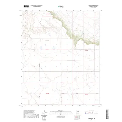
2023 Map of Cunavea Basin
USGS Topo · Published 2023About this map
Cunavea Basin defines the central topography of this Quay County landscape, where the high plains meet a series of dramatic breaks. The terrain is characterized by the deep incisions of Hartford Canyon and Long Canyon in the northeast, marking the transition from the upper plateau to the basin floor. Historically significant water sources, Hart Spring and Alamo Spring, are noted near the rim, highlighting the importance of reliable water in this arid ranching country. A network of rural routes, including Quay Road BE and Quay Road 35, follows the grid of the Public Land Survey System, providing access across the township lines of T7N R28E and T8N R29E. The area maintains its character as a land of wide-open grazing territory and remote canyons.
Find a feature on this map
20 named features on this map. Tap any name to fly to it.
Don’t see what you’re looking for? This feature index may not catch every label — zoom into the map to look around manually.
Map Details
Editions of this 2023 Cunavea Basin Map
This is the sole edition of this map. No revisions or reprints were ever made.
Other maps of this area

1954 · Fort Sumner
USGS Topo · 1:250,000

1954 · Clovis
USGS Topo · 1:250,000

1958 · Fort Sumner
USGS Topo · 1:250,000

1958 · Clovis
USGS Topo · 1:250,000

1968 · Hassell
USGS Topo · 1:24,000

1968 · Ima SE
USGS Topo · 1:24,000
1968 · Ima
USGS Topo · 1:24,000

1970 · Jordan
USGS Topo · 1:24,000

1970 · Quay
USGS Topo · 1:24,000
1970 · Circles S Mesa
USGS Topo · 1:24,000