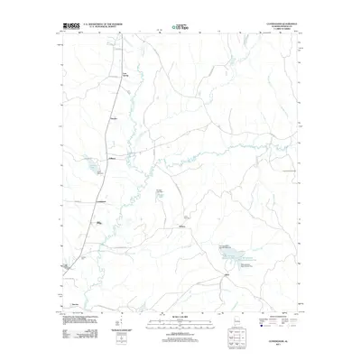
2011 Map of Cunningham
USGS Topo · Published 2011About this map
Lubbub Creek and its tributary, Little Lubbub Creek, define the north-south drainage of this Pickens County landscape. The settlement pattern is characterized by small, dispersed communities linked by a network of county roads and local lanes. From Lois Spring in the north to Stevens in the south, these rural centers often grew around water sources or localized transport junctions. Evidence of mid-century water management is visible through features like Windles Lake Dam and the pair of reservoirs at P M Johnston Lake Number One and P M Johnston Lake Number Two.
Find a feature on this map
46 named features on this map. Tap any name to fly to it.
Don’t see what you’re looking for? This feature index may not catch every label — zoom into the map to look around manually.
Map Details
Editions of this 2011 Cunningham Map
This is the sole edition of this map. No revisions or reprints were ever made.
Other maps of this area

1953 · Birmingham
USGS Topo · 1:250,000

1953 · West Point
USGS Topo · 1:250,000

1956 · Birmingham
USGS Topo · 1:250,000

1957 · Birmingham
USGS Topo · 1:250,000

1958 · West Point
USGS Topo · 1:250,000

1963 · West Point
USGS Topo · 1:250,000

1966 · Reform SW
USGS Topo · 1:24,000

1967 · Carrollton
USGS Topo · 1:24,000

1967 · Gordo
USGS Topo · 1:24,000
1970 · Kirk
USGS Topo · 1:24,000