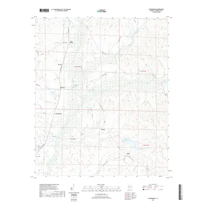
2018 Map of Cunningham
USGS Topo · Published 2018About this map
Lubbub Creek and its many tributaries, including Little Lubbub Creek and Bear Creek, define the topography of this central Pickens County landscape. This 2018 survey details a rural region anchored by small settlements like Beasley, Dillburg, and Cunningham. The transition from upland ridges to lowland creek bottoms is marked by numerous water bodies, such as Pates Lake and Windles Lake, alongside several man-made reservoirs like P M Johnston Lake Number One. Local history is preserved through the locations of the Unity Cemetery and Hopewell Hill Cemetery, which serve as quiet landmarks for the communities of Hickory and Olney. The network of country roads, such as Speeds Mill Road and Unity Cemetery Road, follows the natural drainage patterns and historic land divisions of the Alabama countryside.
Find a feature on this map
46 named features on this map. Tap any name to fly to it.
Don’t see what you’re looking for? This feature index may not catch every label — zoom into the map to look around manually.
Map Details
Editions of this 2018 Cunningham Map
This is the sole edition of this map. No revisions or reprints were ever made.
Other maps of this area

1953 · Birmingham
USGS Topo · 1:250,000

1953 · West Point
USGS Topo · 1:250,000

1956 · Birmingham
USGS Topo · 1:250,000

1957 · Birmingham
USGS Topo · 1:250,000

1958 · West Point
USGS Topo · 1:250,000

1963 · West Point
USGS Topo · 1:250,000

1966 · Reform SW
USGS Topo · 1:24,000

1967 · Carrollton
USGS Topo · 1:24,000

1967 · Gordo
USGS Topo · 1:24,000
1970 · Kirk
USGS Topo · 1:24,000