
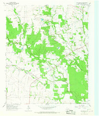
1963 Map of Cunningham
USGS Topo · Published 1964About this map
The Sulphur River drainage system dominates this northeast Texas landscape, where the confluence of the North Sulphur River and the South Sulphur River forms a complex network of wetlands and intermittent creeks. In the early 1960s, the rural community of Cunningham served as the primary settlement hub for this agricultural region, accompanied by smaller locales like Halesboro and Lone Oak. The map reveals the intricate county boundaries where Lamar, Red River, Delta, Hopkins, and Franklin counties converge near the riverbanks. For genealogists, the survey records several local burial grounds including Restland Cem, Woodard Cem, and Morris Chapel Cem. The terrain is characterized by winding waterways such as Mustang Creek and Brushy Creek, which carve through the plains toward Dawson Lake and the main river channel, illustrating the area's natural hydrology before significant modern alterations.
Find a feature on this map
23 named features on this map. Tap any name to fly to it.
Don’t see what you’re looking for? This feature index may not catch every label — zoom into the map to look around manually.
Map Details
Editions of this 1963 Cunningham Map
This is the sole edition of this map. No revisions or reprints were ever made.
Other maps of this area

1953 · Texarkana
USGS Topo · 1:250,000

1956 · Texarkana
USGS Topo · 1:250,000

1962 · Sulphur Bluff
USGS Topo · 1:24,000

1963 · Mitchell Creek
USGS Topo · 1:24,000

1963 · Minter
USGS Topo · 1:24,000

1964 · Deport
USGS Topo · 1:24,000

1964 · Pattonville
USGS Topo · 1:24,000

1964 · Hagansport
USGS Topo · 1:24,000

1964 · Bogata
USGS Topo · 1:24,000
1964 · Line Branch
USGS Topo · 1:24,000