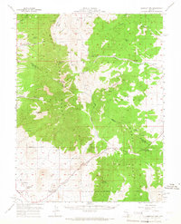
1957 Map of Currant Mtn
USGS Topo · Published 1966About this map
Angleworm Ranch and the Currant Creek School anchor the southern reaches of this mid-century survey, illustrating the isolated ranching and educational outposts that once served the Railroad Valley. The map details the transition from the valley floor into the high elevations of the Humboldt National Forest, where the landscape is defined by the White Pine Co Nye Co boundary line. High-altitude landmarks like Duckwater Peak and White Pine Peak dominate the topography, interspersed with numerous vital water sources such as Horse Track Spr and Hidden Spring.
Find a feature on this map
44 named features on this map. Tap any name to fly to it.
Don’t see what you’re looking for? This feature index may not catch every label — zoom into the map to look around manually.
Map Details
Editions of this 1957 Currant Mtn Map
3 editions found
Other maps of this area

1949 · Treasure Hill
USGS Topo · 1:62,500

1950 · Treasure Hill
USGS Topo · 1:62,500

1951 · Green Springs
USGS Topo · 1:62,500

1956 · Lund
USGS Topo · 1:250,000

1956 · Ely
USGS Topo · 1:250,000

1957 · Currant Mtn
USGS Topo · 1:62,500

1959 · Ely
USGS Topo · 1:250,000

1959 · Preston Reservoir
USGS Topo · 1:62,500

1960 · Lund
USGS Topo · 1:250,000

1963 · Ely
USGS Topo · 1:250,000