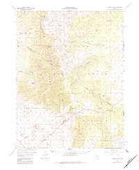
1957 Map of Currant Mtn
USGS Topo · Published 1984About this map
Angleworm Ranch sits at the base of the mountain ranges in this mid-century survey of the Nevada interior. The landscape is defined by its drainage and extraction history, with Blackrock Canyon carving through the northern high ground. The map records several small-scale mining efforts, marked simply as Prospect or Prospects, indicating the persistent search for mineral wealth across the high desert terrain. This document reflects a period when the Bureau of Mines and Geology was actively documenting the State of Nevada's resource potential, showing the intersection of isolated ranching outposts and the speculative mining ventures that characterized the region's sparse settlement patterns.
Find a feature on this map
4 named features on this map. Tap any name to fly to it.
Don’t see what you’re looking for? This feature index may not catch every label — zoom into the map to look around manually.
Map Details
Editions of this 1957 Currant Mtn Map
3 editions found
Other maps of this area

1949 · Treasure Hill
USGS Topo · 1:62,500

1950 · Treasure Hill
USGS Topo · 1:62,500

1951 · Green Springs
USGS Topo · 1:62,500

1956 · Lund
USGS Topo · 1:250,000

1956 · Ely
USGS Topo · 1:250,000

1957 · Currant Mtn
USGS Topo · 1:62,500

1959 · Ely
USGS Topo · 1:250,000

1959 · Preston Reservoir
USGS Topo · 1:62,500

1960 · Lund
USGS Topo · 1:250,000

1963 · Ely
USGS Topo · 1:250,000