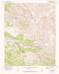
1969 Map of Curry Mountain
USGS Topo · Published 1973About this map
The Firestone Oil Field occupies the northeastern corner of this landscape, marking the industrial activity at the edge of the Alcalde Hills. This 1969 field-checked survey reveals a complex network of mountain grades and canyons where the borders of Fresno and Monterey counties meet. The interior is defined by notable elevations like Curry Mountain and Black Mountain, interspersed with a high density of water sources such as Merrill Pools, Quesada Spring, and Dripping Spring.
Find a feature on this map
97 named features on this map. Tap any name to fly to it.
Don’t see what you’re looking for? This feature index may not catch every label — zoom into the map to look around manually.
Map Details
Editions of this 1969 Curry Mountain Map
2 editions found
Other maps of this area

1912 · Coalinga
USGS Topo · 1:125,000

1914 · Cholame
USGS Topo · 1:125,000

1915 · Priest Valley
USGS Topo · 1:125,000

1915 · Cholame
USGS Topo · 1:125,000

1917 · Cholame
USGS Topo · 1:125,000

1919 · San Miguel
USGS Topo · 1:62,500

1934 · The Dark Hole
USGS Topo · 1:31,680

1936 · Kreyenhagen Hills
USGS Topo · 1:31,680
1937 · The Dark Hole
USGS Topo · 1:31,680
1941 · Kreyenhagen Hills
USGS Topo · 1:31,680