1971 Map of Currys Corner
USGS Topo · Published 1972About this map
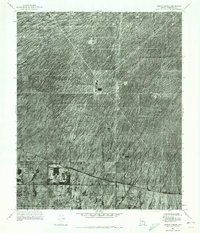
Currys Corner serves as the focal point of this orthophotomosaic, captured during a transitional period in the Arizona desert. The map provides a raw, photographic view of the landscape as it appeared in the early 1970s, dominated by the scrub-covered alluvial fans of Maricopa County. Evidence of earlier water management is visible in the southern portion of the quadrangle, where the trace of the Old Verde Canal cuts across the terrain. The contrast between the undisturbed desert floor and the emerging grid of roads near the settlement highlights the early stages of suburban expansion moving into the desert. This specific type of survey, a controlled orthophotomosaic, preserves the actual visual state of the ground surface, offering researchers a literal view of vegetation patterns and primitive road tracks that standard line maps often omit.
Find a feature on this map
2 named features on this map. Tap any name to fly to it.
Don’t see what you’re looking for? This feature index may not catch every label — zoom into the map to look around manually.
Map Details
Editions of this 1971 Currys Corner Map
This is the sole edition of this map. No revisions or reprints were ever made.
Other maps of this area

1904 · Camelback
USGS Topo · 1:62,500

1906 · Camelsback
USGS Topo · 1:62,500

1930 · Cave Creek
USGS Topo · 1:125,000

1939 · Cave Creek
USGS Topo · 1:125,000

1954 · Phoenix
USGS Topo · 1:250,000

1954 · Mesa
USGS Topo · 1:250,000

1957 · Mesa
USGS Topo · 1:250,000

1957 · Phoenix
USGS Topo · 1:250,000

1958 · Mesa
USGS Topo · 1:250,000

1958 · Phoenix
USGS Topo · 1:250,000