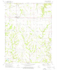
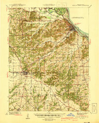
1973 Map of Curryville
USGS Topo · Published 1977About this map
Curryville stands as the primary rail-side settlement in this portion of Pike County, oriented along the Illinois Central Gulf railroad line. The map illustrates a landscape defined by the drainage systems of South Spencer Creek, Cuivre Creek, and the North Fork Cuivre River. Rural life in the 1970s is evidenced by several scattered educational and religious landmarks, including multiple locations labeled Amish Sch, as well as Concord Ch and Kitty Ch. Smaller hubs like New Harmony and Farmer punctuate the township divisions of Spencer, Cuivre, Indian, and Ashley. Beyond the agricultural grid, specialized land uses appear such as a Fish Farm near Shady Creek and several Quarry sites. The inclusion of visible fence and field lines provides a high-resolution look at property boundaries and land management in the mid-20th century.
Find a feature on this map
29 named features on this map. Tap any name to fly to it.
Don’t see what you’re looking for? This feature index may not catch every label — zoom into the map to look around manually.
Map Details
Editions of this 1973 Curryville Map
This is the sole edition of this map. No revisions or reprints were ever made.
Other maps of this area

1890 · Louisiana
USGS Topo · 1:125,000
1937 · Silex
USGS Topo · 1:62,500
1937 · Bowling Green
USGS Topo · 1:62,500
1939 · Silex
USGS Topo · 1:48,000
1940 · Bowling Green
USGS Topo · 1:62,500
1942 · Bellflower
USGS Topo · 1:62,500
1943 · Vandalia
USGS Topo · 1:62,500

1945 · Bellflower
USGS Topo · 1:62,500
1945 · Vandalia
USGS Topo · 1:62,500

1948 · Quincy
USGS Topo · 1:250,000