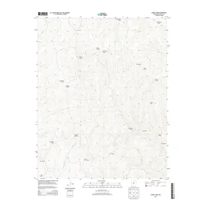
2013 Map of Curtis Camp
USGS Topo · Published 2013About this map
Curtis Camp sits at the head of a complex drainage network in northern New Mexico, serving as a rare named settlement marker in a landscape defined by deep, branching ravines. The terrain is intricately carved by seasonal watercourses, with Crow Cr and its many tributaries, such as Saltpeter Cr and Five Dollar Cr, dictating the local topography. This 2013 survey illustrates the high-elevation canyon systems of Colfax County, where place names often reflect early land use or resource discovery. Notable examples include Coal Canyon, Saltpeter Canyon, and Shotgun Canyon, which suggest a history of prospecting and hunting. The map also records several distinct geographic features like McClellan Canyon in the northeast and Prairie Crow Canyon to the south, providing a detailed anatomical view of this portion of the Sangre de Cristo foothills through its contour-defined ridges and valleys.
Find a feature on this map
21 named features on this map. Tap any name to fly to it.
Don’t see what you’re looking for? This feature index may not catch every label — zoom into the map to look around manually.
Map Details
Editions of this 2013 Curtis Camp Map
This is the sole edition of this map. No revisions or reprints were ever made.
Other maps of this area

1915 · Brilliant
USGS Topo · 1:62,500

1915 · Koehler
USGS Topo · 1:62,500

1917 · Koehler
USGS Topo · 1:62,500

1954 · Raton
USGS Topo · 1:250,000

1955 · Cimarron
USGS Topo · 1:62,500

1958 · Raton
USGS Topo · 1:250,000

1962 · Casa Grande
USGS Topo · 1:62,500

1971 · Saltpeter Mountain
USGS Topo · 1:24,000
1971 · Curtis Camp
USGS Topo · 1:24,000
1971 · Red River Peak
USGS Topo · 1:24,000