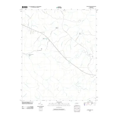
2010 Map of Curtistown
USGS Topo · Published 2010About this map
The Cumberland Plateau Observatory stands as a prominent landmark in this landscape defined by the deep incisions of the Rocky River and its numerous tributaries. Settled along the ridges and hollows of Warren County, the area is connected by a network of rural routes such as Rocky River Rd and Curtistown Rd. Local history is anchored by the Pleasant Hill Cemetery and the presence of Powers Mine to the east, indicating the region's intersection of community life and resource extraction. The topography is notably marked by geological features like High Rock and several named ravines, including Laurel Creek Gulch and Dry Creek Gulch. Water management is evident at O'Neal Lake, where the O'Neal Lake Dam regulates the flow of local branches near the settlement area of Curtistown.
Find a feature on this map
42 named features on this map. Tap any name to fly to it.
Don’t see what you’re looking for? This feature index may not catch every label — zoom into the map to look around manually.
Map Details
Editions of this 2010 Curtistown Map
This is the sole edition of this map. No revisions or reprints were ever made.
Other maps of this area

1888 · Chattanooga
USGS Topo · 1:125,000

1892 · Pikeville
USGS Topo · 1:125,000

1893 · Mc Minnville
USGS Topo · 1:125,000

1893 · Chattanooga
USGS Topo · 1:125,000

1895 · Mc Minnville
USGS Topo · 1:125,000

1895 · Sewanee
USGS Topo · 1:125,000

1895 · Pikeville
USGS Topo · 1:125,000

1935 · Smart Mountain
USGS Topo · 1:24,000
1936 · Savage Point
USGS Topo · 1:24,000
1946 · Savage Point
USGS Topo · 1:24,000