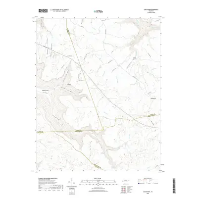
2019 Map of Curtistown
USGS Topo · Published 2019About this map
Curtistown and the rural highlands of the Cumberland Plateau are meticulously detailed in this recent record of Warren, Van Buren, Sequatchie, and Grundy counties. The landscape is defined by its deep drainages, including Dyer Gulch and Laurel Creek Gulch, which carve through the high ground. Notable landmarks like High Rock overlook Spring Creek Hollow, while the waters of the Rocky River and Bee Fork trace the complex topography. This map highlights the distribution of isolated settlements such as Spring Creek and Chalybeate, connected by a network of winding roads like Harrison Ferry Rd and George Holland Rd. The presence of the Pleasant Hill Cem and O'Neal Lake adds specific points of interest for those studying the local history and geography of these intersecting Tennessee counties.
Find a feature on this map
56 named features on this map. Tap any name to fly to it.
Don’t see what you’re looking for? This feature index may not catch every label — zoom into the map to look around manually.
Map Details
Editions of this 2019 Curtistown Map
This is the sole edition of this map. No revisions or reprints were ever made.
Other maps of this area

1888 · Chattanooga
USGS Topo · 1:125,000

1892 · Pikeville
USGS Topo · 1:125,000

1893 · Mc Minnville
USGS Topo · 1:125,000

1893 · Chattanooga
USGS Topo · 1:125,000

1895 · Mc Minnville
USGS Topo · 1:125,000

1895 · Sewanee
USGS Topo · 1:125,000

1895 · Pikeville
USGS Topo · 1:125,000

1935 · Smart Mountain
USGS Topo · 1:24,000
1936 · Savage Point
USGS Topo · 1:24,000
1946 · Savage Point
USGS Topo · 1:24,000