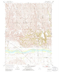
1955 Map of Cushing
USGS Topo · Published 1986About this map
The Cushing settlement and the wide Loup Valley define this mid-century landscape in Howard County, Nebraska. The Chicago Burlington and Quincy railroad tracks parallel the Loup River, passing just south of the town site and providing a vital link for the agricultural community. This 1955 survey provides a detailed look at the rural infrastructure of the era, recording numerous small schoolhouses like School No 51 and School No 53, as well as sites already falling into disuse such as School No 80 (Abandoned). Near the northern bluffs, the Rock Creek Ch and its adjacent Rock Creek Cem serve as important landmarks for genealogical research. The map also delineates the Old Indian Reservation Boundary, a significant historical marker cutting through the prairie north of the river.
Find a feature on this map
20 named features on this map. Tap any name to fly to it.
Don’t see what you’re looking for? This feature index may not catch every label — zoom into the map to look around manually.
Map Details
Editions of this 1955 Cushing Map
2 editions found
Other maps of this area

1899 · St. Paul
USGS Topo · 1:125,000

1954 · Wolbach
USGS Topo · 1:24,000

1954 · Wolbach NE
USGS Topo · 1:24,000

1954 · Belgrade NW
USGS Topo · 1:24,000

1955 · Belgrade SW
USGS Topo · 1:24,000

1955 · Broken Bow
USGS Topo · 1:250,000

1955 · Wolbach SW
USGS Topo · 1:24,000

1955 · Cushing
USGS Topo · 1:24,000

1956 · Broken Bow
USGS Topo · 1:250,000
1960 · St. Paul
USGS Topo · 1:24,000