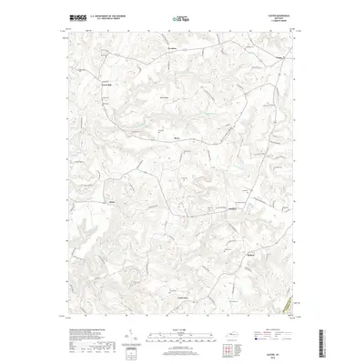
2019 Map of Custer
USGS Topo · Published 2019About this map
Hudson and Fairfield anchor this rural landscape in Breckinridge County, where the terrain is deeply carved by the N Fork Rough River and its numerous tributaries. The map reveals a high density of family and community burial grounds, such as Goodhope Cem, Drane Cem, and Pile Cem, reflecting generations of local settlement and genealogical history across Marks Ridge and Duncan Valley. The hydrography of the region is notably intricate, with Muddy Prong, Clear Prong, and White Oak Cr winding through the hollows. Small hamlets like Woodrow, Buras, and Locust Hill are connected by a network of named country roads and lanes, such as Garfield Woodrow Rd and Locust Hill-Buras-Custer Rd, which trace the high ridges and valley floors. This survey documents the persistent rural character of the area, defined by its traditional farm-to-market road patterns and well-preserved namesake landmarks.
Find a feature on this map
89 named features on this map. Tap any name to fly to it.
Don’t see what you’re looking for? This feature index may not catch every label — zoom into the map to look around manually.
Map Details
Editions of this 2019 Custer Map
This is the sole edition of this map. No revisions or reprints were ever made.
Other maps of this area

1928 · Hardinsburg
USGS Topo · 1:48,000

1931 · Hardinsburg
USGS Topo · 1:62,500

1932 · Big Clifty
USGS Topo · 1:62,500

1941 · Ekron
USGS Topo · 1:62,500

1947 · Hardinsburg
USGS Topo · 1:24,000

1947 · Garfield
USGS Topo · 1:24,000

1947 · Hardinsburg
USGS Topo · 1:62,500

1947 · Ekron
USGS Topo · 1:62,500
1948 · Big Spring
USGS Topo · 1:24,000

1949 · Constantine
USGS Topo · 1:24,000