1922 Map of Custer
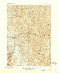
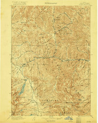
USGS Topo · Published 1946About this map
Stanley Basin and the surrounding high country of the Challis National Forest dominate this 1910s era survey. The mining settlements of Custer and Bonanza are shown along the upper reaches of the Salmon River, connected by early mountain trails. This landscape reflects the peak of early 20th-century resource extraction, anchored by industrial sites such as the Sunbeam Mine and Fisher Mill. Water management for these operations and local transit is evidenced by the presence of the Sunbeam Dam and the Valley Creek Ranger Station. Further south, the dramatic transition to the Sawtooth Mountains is marked by Redfish Lake and Little Redfish Lake, providing a clear view of the region before modern highway development fully opened the area to tourism. The map also traces the small community at Obsidian and various high-altitude landmarks like Patterson Peak and Railroad Ridge.
Find a feature on this map
105 named features on this map. Tap any name to fly to it.
Don’t see what you’re looking for? This feature index may not catch every label — zoom into the map to look around manually.
Map Details
Editions of this 1922 Custer Map
3 editions found
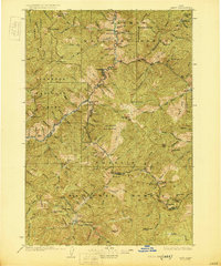
Other maps of this area

1891 · Bear Valley
USGS Topo · 1:125,000

1893 · Bear Valley
USGS Topo · 1:125,000

1894 · Rocky Bar
USGS Topo · 1:125,000

1895 · Hailey
USGS Topo · 1:125,000

1897 · Hailey
USGS Topo · 1:125,000

1900 · Sawtooth
USGS Topo · 1:125,000

1919 · Custer
USGS Topo · 1:125,000

1922 · Custer
USGS Topo · 1:125,000

1929 · Bayhorse
USGS Topo · 1:125,000
1930 · Casto
USGS Topo · 1:125,000