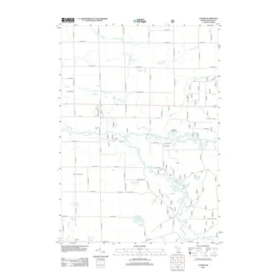
2012 Map of Custer
USGS Topo · Published 2012About this map
The Pere Marquette River and its winding tributary, the Big S Br Pere Marquette River, dominate this West Michigan landscape, carving a complex path through the glacial terrain of Mason County. This survey captures the rural character of the region, where the grid of farm roads is interrupted only by natural water bodies like Whelan Lake and Bartons Lake. The local infrastructure is anchored by the village center, where the Post Office and a network of residential streets such as S Madison Ave meet. Genealogists will find the locations of established burial grounds useful, including Riverside Cem, Emmanuel Lutheran Cem, and Lakeside Cem near Clancy Lake. The inclusion of the Custer Lookout Tower and Thorn Airport provides insight into mid-century and modern land management and regional aviation, while the numerous small drains like Frog Paradise Drain illustrate the local efforts to manage the wetlands for agriculture.
Find a feature on this map
68 named features on this map. Tap any name to fly to it.
Don’t see what you’re looking for? This feature index may not catch every label — zoom into the map to look around manually.
Map Details
Editions of this 2012 Custer Map
This is the sole edition of this map. No revisions or reprints were ever made.
Other maps of this area

1931 · Custer NW
USGS Topo · 1:31,680

1931 · Custer SW
USGS Topo · 1:31,680

1931 · Custer NE
USGS Topo · 1:31,680

1931 · Manistee SE
USGS Topo · 1:31,680

1931 · Freesoil SW
USGS Topo · 1:31,680

1931 · Custer SE
USGS Topo · 1:31,680

1932 · Freesoil SE
USGS Topo · 1:31,680

1932 · Ludington NE
USGS Topo · 1:31,680

1932 · Ludington SE
USGS Topo · 1:31,680

1954 · Milwaukee
USGS Topo · 1:250,000