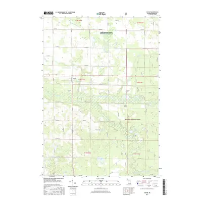
2017 Map of Custer
USGS Topo · Published 2017About this map
The Pere Marquette River and its Big South Branch anchor this landscape, flowing through a region dominated by the Manistee National Forest. The village of Custer sits at the northern edge of the river valley, serving as a central hub for the surrounding township. This area is characterized by numerous small water bodies including McKinzie Lake, Bailey Lake, and Whelan Lake, which are scattered among a network of rural roads such as E Hansen Rd and N Custer Rd. Local history is preserved in several burial grounds, including Riverside Cem, Lakeside Cem, and the Emmanuel Lutheran Cem. To the east of the village, Thorn Airport provides a small aviation point amidst the dense forest and marshy lowlands of Weldon Cr and Hatting Cr. The map reflects a landscape where managed federal forest land and private agricultural interests, such as those noted by the Farm Service Agency Interest of Michigan, exist side-by-side.
Find a feature on this map
71 named features on this map. Tap any name to fly to it.
Don’t see what you’re looking for? This feature index may not catch every label — zoom into the map to look around manually.
Map Details
Editions of this 2017 Custer Map
This is the sole edition of this map. No revisions or reprints were ever made.
Other maps of this area

1931 · Custer NW
USGS Topo · 1:31,680

1931 · Custer SW
USGS Topo · 1:31,680

1931 · Custer NE
USGS Topo · 1:31,680

1931 · Manistee SE
USGS Topo · 1:31,680

1931 · Freesoil SW
USGS Topo · 1:31,680

1931 · Custer SE
USGS Topo · 1:31,680

1932 · Freesoil SE
USGS Topo · 1:31,680

1932 · Ludington NE
USGS Topo · 1:31,680

1932 · Ludington SE
USGS Topo · 1:31,680

1954 · Milwaukee
USGS Topo · 1:250,000