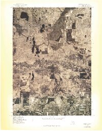
1976 Map of Custer NE
USGS Topo · Published 1976About this map
Pere Marquette River meanders in tight, complex oxbows across the central landscape of this 1976 orthophotograph, providing a rare visual record of the river's unchannelized course through Mason County. The aerial imagery captures the distinct spatial relationship between the small settlements of Tallman and Walhalla, set against a dense mosaic of woodlots and cleared agricultural plots. Because this is an orthophotoquad rather than a traditional line-drawn map, the sheet preserves the precise textures of the vegetation and the winding dirt paths that serve these rural communities during the mid-1970s. For researchers, the contrast between the dark, marshy river corridor and the structured road grid offers a clear view of how geography dictated local development patterns in this corner of Michigan.
Find a feature on this map
3 named features on this map. Tap any name to fly to it.
Don’t see what you’re looking for? This feature index may not catch every label — zoom into the map to look around manually.
Map Details
Editions of this 1976 Custer NE Map
This is the sole edition of this map. No revisions or reprints were ever made.
Other maps of this area

1931 · Custer NW
USGS Topo · 1:31,680

1931 · Baldwin NW
USGS Topo · 1:31,680

1931 · Custer SW
USGS Topo · 1:31,680

1931 · Custer NE
USGS Topo · 1:31,680

1931 · Freesoil SW
USGS Topo · 1:31,680

1931 · Custer SE
USGS Topo · 1:31,680

1932 · Freesoil SE
USGS Topo · 1:31,680

1933 · Peacock SW
USGS Topo · 1:31,680

1954 · Traverse City
USGS Topo · 1:250,000

1954 · Milwaukee
USGS Topo · 1:250,000