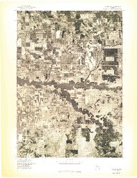
1976 Map of Custer NW
USGS Topo · Published 1976About this map
Pere Marquette River meanders sharply through this mid-1970s orthophoto, its winding path creating a corridor of dense vegetation amidst a landscape of geometric agricultural fields and woodlots. In the northwest, the settlement of Custer sits at a crossroads, serving as the primary hub for the surrounding rural Mason County community. This orthophotographic study, derived from high-altitude aerial imagery, reveals the precise distribution of farmland and the drainage patterns that define this part of West Michigan. The contrast between the river's natural, erratic course and the straight-line grid of the local roads illustrates the intersection of glacial geography and human organization during this era.
Find a feature on this map
2 named features on this map. Tap any name to fly to it.
Don’t see what you’re looking for? This feature index may not catch every label — zoom into the map to look around manually.
Map Details
Editions of this 1976 Custer NW Map
This is the sole edition of this map. No revisions or reprints were ever made.
Other maps of this area

1931 · Custer NW
USGS Topo · 1:31,680

1931 · Custer SW
USGS Topo · 1:31,680

1931 · Custer NE
USGS Topo · 1:31,680

1931 · Manistee SE
USGS Topo · 1:31,680

1931 · Freesoil SW
USGS Topo · 1:31,680

1931 · Custer SE
USGS Topo · 1:31,680

1932 · Freesoil SE
USGS Topo · 1:31,680

1932 · Ludington NE
USGS Topo · 1:31,680

1932 · Ludington SE
USGS Topo · 1:31,680

1954 · Milwaukee
USGS Topo · 1:250,000