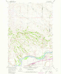
1960 Map of Custer
USGS Topo · Published 1980About this map
The town of Custer serves as the focal point of this landscape, situated at the intersection of the Yellowstone River and the Northern Pacific Railroad. In the late 1950s and through the photorevisions of the 1970s, the area's agricultural and transportation infrastructure remained deeply tied to the river valley, where the Custer Canal manages water flow for local needs. North of the valley, the terrain rises into a complex network of coulees and hills, including the prominent Fivemile Hill and the drainage of Big Fivemile Creek.
Find a feature on this map
19 named features on this map. Tap any name to fly to it.
Don’t see what you’re looking for? This feature index may not catch every label — zoom into the map to look around manually.
Map Details
Editions of this 1960 Custer Map
Other maps of this area

1954 · Forsyth
USGS Topo · 1:250,000

1957 · Forsyth
USGS Topo · 1:250,000

1958 · Forsyth
USGS Topo · 1:250,000

1960 · Bighorn
USGS Topo · 1:24,000

1960 · Coal Bank Creek
USGS Topo · 1:24,000

1960 · Custer
USGS Topo · 1:24,000

1960 · Rancher Cemetery
USGS Topo · 1:24,000

1960 · Marsh Coulee
USGS Topo · 1:24,000

1960 · Waco
USGS Topo · 1:24,000
1960 · Mission Creek
USGS Topo · 1:24,000