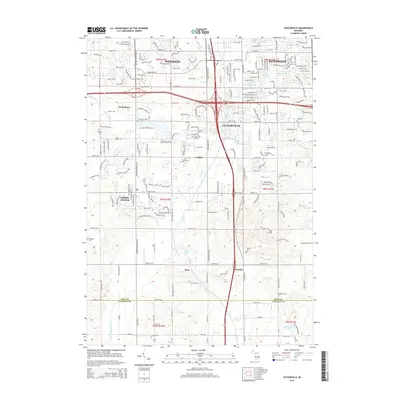
2014 Map of Cutlerville
USGS Topo · Published 2014About this map
Cutlerville and the southern reaches of Wyoming and Kentwood sit at the center of this suburbanizing landscape on the edge of the Kent Co and Allegan Co line. The map records a transition from established residential grids in the north to more dispersed rural tracts toward the south, where the drainage of Buck Creek and Dorr and Byron Drain cross the terrain. Significant local history is preserved in a high density of burial grounds, including Pine Hill Cem, Boynton Cem, and Kent Memorial Gardens. Transportation corridors like Division Ave S and Clyde Park Ave SW anchor the map, while the name Byron Station points toward the rail history of Byron Center. Natural landmarks like Hilton Lake and Dias Hill punctuate the landscape, alongside smaller settlements such as Ross, Carlisle, and Corinth.
Find a feature on this map
39 named features on this map. Tap any name to fly to it.
Don’t see what you’re looking for? This feature index may not catch every label — zoom into the map to look around manually.
Map Details
Editions of this 2014 Cutlerville Map
This is the sole edition of this map. No revisions or reprints were ever made.
Other maps of this area

1914 · Grand Rapids
USGS Topo · 1:62,500

1943 · Grand Rapids
USGS Topo · 1:62,500

1958 · Allegan
USGS Topo · 1:62,500

1958 · Grandville
USGS Topo · 1:62,500

1958 · Grandville
USGS Topo · 1:24,000

1958 · Grand Rapids
USGS Topo · 1:250,000

1959 · Wayland
USGS Topo · 1:62,500

1961 · Grand Rapids
USGS Topo · 1:250,000

1962 · Grand Rapids
USGS Topo · 1:250,000
1967 · Grand Rapids West
USGS Topo · 1:24,000