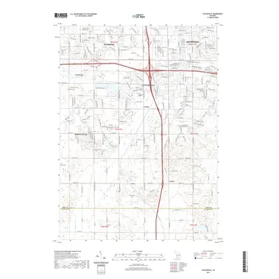
2019 Map of Cutlerville
USGS Topo · Published 2019About this map
Cutlerville and its surrounding suburbs near the Kent Co and Allegan Co line show the modern development patterns south of Grand Rapids. The landscape is a network of residential expansion into former agricultural lands, marked by numerous local burial sites such as Winegar Cem, Boynton Cem, and Winchester Cem that hint at the area's earlier rural history. Local industry and transit are anchored by the Byron Depot and a dense web of roads serving established communities like Byron Center, Kentwood, and Wyoming.
Find a feature on this map
133 named features on this map. Tap any name to fly to it.
Don’t see what you’re looking for? This feature index may not catch every label — zoom into the map to look around manually.
Map Details
Editions of this 2019 Cutlerville Map
This is the sole edition of this map. No revisions or reprints were ever made.
Other maps of this area

1914 · Grand Rapids
USGS Topo · 1:62,500

1943 · Grand Rapids
USGS Topo · 1:62,500

1958 · Allegan
USGS Topo · 1:62,500

1958 · Grandville
USGS Topo · 1:62,500

1958 · Grandville
USGS Topo · 1:24,000

1958 · Grand Rapids
USGS Topo · 1:250,000

1959 · Wayland
USGS Topo · 1:62,500

1961 · Grand Rapids
USGS Topo · 1:250,000

1962 · Grand Rapids
USGS Topo · 1:250,000
1967 · Grand Rapids West
USGS Topo · 1:24,000