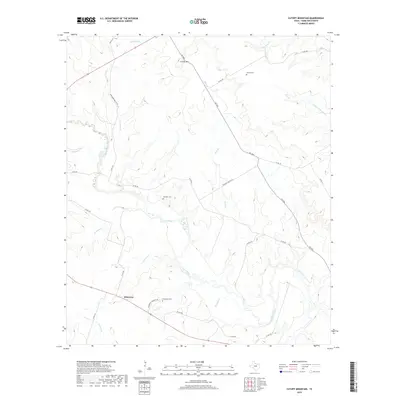
2019 Map of Cutoff Mountain
USGS Topo · Published 2019About this map
The winding Leon River defines the central topography of this Hamilton County landscape, carving a deep valley through the limestone hills. In the southwest corner, the small community of Whiteway sits at the junction of several rural routes, including the historically significant Jonesboro Mail Rt Rd. This area reflects a long-established ranching and farming heritage, evidenced by the scattered family and community burial grounds that dot the high ground above the river's floodplains. Genealogists will find the locations of the Evergreen Cem, Bullman Cem, and Viertel Cem particularly useful for tracing local family lineages. The terrain is marked by significant elevation changes, most notably at Cutoff Mtn, while a network of seasonal creeks like Beck Br and Farnash Cr drain the surrounding plateaus into the primary river system.
Find a feature on this map
31 named features on this map. Tap any name to fly to it.
Don’t see what you’re looking for? This feature index may not catch every label — zoom into the map to look around manually.
Map Details
Editions of this 2019 Cutoff Mountain Map
This is the sole edition of this map. No revisions or reprints were ever made.
Other maps of this area

1888 · Hamilton
USGS Topo · 1:125,000

1888 · Meridian
USGS Topo · 1:125,000

1894 · Hamilton
USGS Topo · 1:125,000

1894 · Meridian
USGS Topo · 1:125,000

1954 · Brownwood
USGS Topo · 1:250,000

1954 · Waco
USGS Topo · 1:250,000

1955 · Waco
USGS Topo · 1:250,000
1955 · Ater
USGS Topo · 1:24,000
1956 · Jonesboro
USGS Topo · 1:24,000

1956 · Cranfills Gap
USGS Topo · 1:24,000