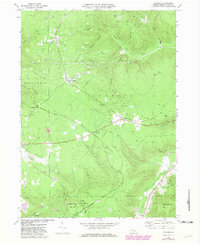
1969 Map of Cyclone
USGS Topo · Published 1981About this map
Kinzua Bridge State Park and the rugged hollows of Keating and Lafayette townships define this portion of the Pennsylvania Alleghenies. The landscape is heavily marked by energy extraction, with a dense concentration of Oil Wells and Gas Wells stretching from Gifford south through Cyclone and Ormsby. This industrial character is further emphasized by the presence of Strip Mines and several pipelines traversing the terrain between Threemile Run and McQuen Hollow.
Find a feature on this map
39 named features on this map. Tap any name to fly to it.
Don’t see what you’re looking for? This feature index may not catch every label — zoom into the map to look around manually.
Map Details
Editions of this 1969 Cyclone Map
2 editions found
Other maps of this area

1924 · Bradford
USGS Topo · 1:62,500

1926 · Bradford
USGS Topo · 1:62,500

1933 · Smethport
USGS Topo · 1:62,500

1935 · Mt. Jewett
USGS Topo · 1:48,000

1937 · Smethport
USGS Topo · 1:62,500

1940 · Mt. Jewett
USGS Topo · 1:62,500

1941 · Bradford
USGS Topo · 1:62,500

1944 · Bradford
USGS Topo · 1:62,500

1948 · Crosby
USGS Topo · 1:62,500
1948 · Crosby
USGS Topo · 1:24,000
Featured Places
- Lafayette Township, PA
- McKean, Keating Township
- Bingham, Lafayette Township
- Wolf Run, Keating Township
- Gaffney, Hamlin Township