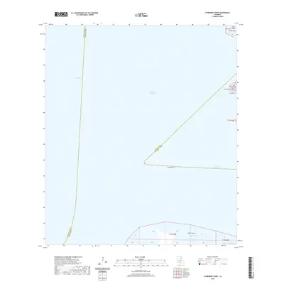
2020 Map of Cypremort Point
USGS Topo · Published 2020About this map
Cypremort Point serves as the focal point of this coastal survey, where the terrestrial marshes of Iberia Parish meet the expansive waters of Vermilion Bay and West Cote Blanche Bay. The map highlights a landscape dominated by tidal hydrology and navigation, featuring the Acadiana Navigation Channel cutting through the open water to facilitate maritime transit. Significant coastal landforms such as Shark Island, Blue Point, and the northern reaches of Marsh Island are clearly delineated, illustrating the complex shoreline of southern Louisiana. Local infrastructure is minimal, centered primarily around Bayview Rd at the point itself. The presence of Terrapin Reef and intricate waterways like Bayou Lucien and Bird Island Bayou reveal a geography shaped by the constant interaction of the Gulf drainage systems and the low-lying wetlands.
Find a feature on this map
13 named features on this map. Tap any name to fly to it.
Don’t see what you’re looking for? This feature index may not catch every label — zoom into the map to look around manually.
Map Details
Editions of this 2020 Cypremort Point Map
This is the sole edition of this map. No revisions or reprints were ever made.
Other maps of this area

1932 · Bayou Blanc
USGS Topo · 1:31,680

1932 · Abbeville SE
USGS Topo · 1:31,680

1937 · Derouen
USGS Topo · 1:62,500

1945 · New Orleans
USGS Topo · 1:250,000

1946 · Redfish Point NE
USGS Topo · 1:31,680

1946 · Redfish Point SE
USGS Topo · 1:31,680
1948 · Bayou Blanc
USGS Topo · 1:24,000

1948 · Cypremort Point
USGS Topo · 1:24,000

1949 · Cypremort Pt
USGS Topo · 1:31,680

1949 · Bayou Lucien
USGS Topo · 1:31,680