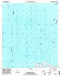
1994 Map of Cypremort Point
USGS Topo · Published 1998About this map
Cypremort Point stands as a prominent coastal finger extending into the convergence of Vermilion Bay and West Cote Blanche Bay in this 1994 USGS survey. The landscape is defined by the expansive marshlands and tidal networks of the Russell Sage Foundation-Marsh Island State Wildlife Refuge, which occupies the southern portion of the sheet. This area illustrates the coastal Louisiana transition from open water to protected wetlands, marked by features such as Marsh Island and Bird Island Bayou. An active industrial presence is indicated by the Oil and Gas Field located in the bay, supported by a Communication Tower and a Light for maritime navigation. Smaller terrain markers like Shark Island, Blue Point, and Terrapin Reef help define the shoreline as it existed in the mid-1990s.
Find a feature on this map
16 named features on this map. Tap any name to fly to it.
Don’t see what you’re looking for? This feature index may not catch every label — zoom into the map to look around manually.
Map Details
Editions of this 1994 Cypremort Point Map
This is the sole edition of this map. No revisions or reprints were ever made.
Other maps of this area

1932 · Bayou Blanc
USGS Topo · 1:31,680

1932 · Abbeville SE
USGS Topo · 1:31,680

1937 · Derouen
USGS Topo · 1:62,500

1945 · New Orleans
USGS Topo · 1:250,000

1946 · Redfish Point NE
USGS Topo · 1:31,680

1946 · Redfish Point SE
USGS Topo · 1:31,680
1948 · Bayou Blanc
USGS Topo · 1:24,000

1948 · Cypremort Point
USGS Topo · 1:24,000

1949 · Cypremort Pt
USGS Topo · 1:31,680

1949 · Bayou Lucien
USGS Topo · 1:31,680