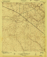
1915 Map of Cypress
USGS Topo · Published 1915About this map
Cypress serves as the primary rail-side hub of this 1915 Harris County landscape, positioned where the Houston and Texas Central railroad intersects the Houston Central and Texas Washington Road. The area is defined by the drainage networks of Big Cypress Creek, Little Cypress Creek, and Dinner Creek, which dictate the placement of early 20th-century ranching and social sites. Notable landmarks like the Houston Hot Well and the Cypress Gun Club suggest a region used for recreation and localized industry alongside traditional agriculture. Educational centers such as Big Cypress School and Brink School are visible, while individual holdings like Bains Ranch highlight the rural settlement patterns before the extensive suburban expansion of the Houston area. Surveyed with a one-foot contour interval, the map provides an incredibly precise look at the nearly flat topography characteristic of the Gulf Coastal Plain.
Find a feature on this map
11 named features on this map. Tap any name to fly to it.
Don’t see what you’re looking for? This feature index may not catch every label — zoom into the map to look around manually.
Map Details
Editions of this 1915 Cypress Map
3 editions found
Other maps of this area

1915 · Cypress
USGS Topo · 1:24,000

1915 · Katy
USGS Topo · 1:24,000

1915 · Addicks
USGS Topo · 1:24,000

1915 · Hillendahl
USGS Topo · 1:24,000

1916 · Rose Hill
USGS Topo · 1:24,000

1916 · Louetta
USGS Topo · 1:24,000

1916 · Hockley
USGS Topo · 1:24,000

1916 · Satsuma
USGS Topo · 1:24,000

1916 · Swanson
USGS Topo · 1:24,000

1918 · Cypress
USGS Topo · 1:31,680