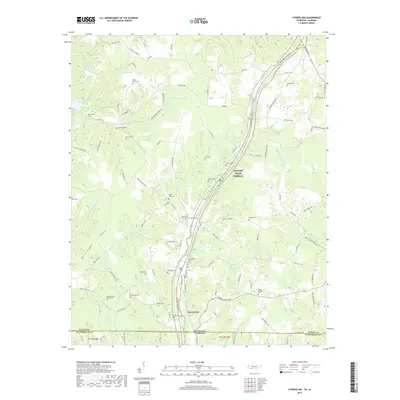
2019 Map of Cypress Inn
USGS Topo · Published 2019About this map
Cypress Inn serves as the focal point for this landscape along the Tennessee-Alabama state line, where the winding route of the Natchez Trace Parkway cuts diagonally through the hills of Wayne County. The map is notably dense with small family and community burial grounds, such as Old Chestnut Grove Cem, Old Darby Cem, and Jackson Cem, suggesting a long-established pattern of rural settlement. These sites are frequently situated on high ground near prominent landforms like Bevis Ridge and Cromwell Ridge. The hydrology of the area is defined by the numerous branches feeding into Cypress Cr, including Weatherford Cr and Barkley Branch. This 2019 survey documents the modern road network, from Co Hwy 915 to local lanes like Bevis School Rd, preserving the names of generations of residents in the landscape's nomenclature.
Find a feature on this map
106 named features on this map. Tap any name to fly to it.
Don’t see what you’re looking for? This feature index may not catch every label — zoom into the map to look around manually.
Map Details
Editions of this 2019 Cypress Inn Map
This is the sole edition of this map. No revisions or reprints were ever made.
Other maps of this area

1905 · Waynesboro
USGS Topo · 1:125,000

1914 · Muscle Shoals
USGS Topo · 1:48,000

1916 · Muscle Shoals
USGS Topo · 1:62,500

1924 · Gravelly Springs
USGS Topo · 1:48,000

1926 · Gravelly Springs
USGS Topo · 1:62,500

1935 · Wright
USGS Topo · 1:24,000

1936 · Collinwood
USGS Topo · 1:24,000

1936 · Light
USGS Topo · 1:24,000

1936 · Threet
USGS Topo · 1:24,000

1936 · Cypress Inn
USGS Topo · 1:24,000