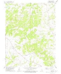
1978 Map of Cyrene
USGS Topo · Published 1978About this map
Cyrene and Edgewood anchor this portion of Pike County in the late 1970s, where the landscape is defined by the headwaters of numerous creeks draining the upland terrain. The map captures a rural social geography centered on dispersed family-named landmarks and country churches. Local history is etched into the land through numerous small burial grounds, including Hickerson Cem, Stark Cem, and Dover Cem, often situated on high ground near drainage divides.
Find a feature on this map
26 named features on this map. Tap any name to fly to it.
Don’t see what you’re looking for? This feature index may not catch every label — zoom into the map to look around manually.
Map Details
Editions of this 1978 Cyrene Map
2 editions found
Other maps of this area

1890 · Louisiana
USGS Topo · 1:125,000

1930 · Nebo
USGS Topo · 1:62,500

1934 · Nebo
USGS Topo · 1:48,000

1934 · Elsberry
USGS Topo · 1:48,000

1937 · Silex
USGS Topo · 1:62,500

1937 · Bowling Green
USGS Topo · 1:62,500

1939 · Silex
USGS Topo · 1:48,000

1940 · Bowling Green
USGS Topo · 1:62,500

1942 · Nebo
USGS Topo · 1:62,500

1942 · Elsberry
USGS Topo · 1:62,500