
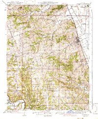
1942 Map of Elsberry
USGS Topo · Published 1942About this map
Elsberry stands as a primary rail hub along the Chicago Burlington and Quincy railroad, overlooking the fertile bottomlands near Old Kings Lake. The surrounding terrain of Lincoln and Pike Counties is defined by the winding course of the Cuivre River and its various forks, supporting a dense network of rural infrastructure during the early 1940s. A striking number of country schools, such as Sand Ridge Sch, Barton Sch, and Connick Sch, are scattered across the landscape, illustrating the decentralized educational system of the era.
Find a feature on this map
101 named features on this map. Tap any name to fly to it.
Don’t see what you’re looking for? This feature index may not catch every label — zoom into the map to look around manually.
Map Details
Editions of this 1942 Elsberry Map
2 editions found
Other maps of this area

1890 · Louisiana
USGS Topo · 1:125,000

1890 · Hermann
USGS Topo · 1:125,000

1903 · O'Fallon
USGS Topo · 1:125,000

1930 · Pearl
USGS Topo · 1:62,500

1930 · Nebo
USGS Topo · 1:62,500

1930 · Hardin
USGS Topo · 1:62,500

1931 · Brussels
USGS Topo · 1:62,500

1934 · Nebo
USGS Topo · 1:48,000

1934 · Elsberry
USGS Topo · 1:48,000

1934 · Hardin
USGS Topo · 1:62,500