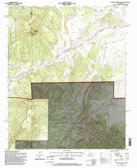
1995 Map of D Cross Mountain
USGS Topo · Published 1998About this map
D Cross Mountain rises as a prominent landmark in this high-altitude landscape where the Datil Mountains and Gallinas Mountains converge. The terrain is defined by a network of drainage systems, including Alamocita Creek and Miguel Chavez Canyon, which carve through the volcanic and sedimentary layers of the Cibola National Forest. This 1990s-era revision, based on mid-century topography, documents the land-use patterns of western Socorro County. Evidence of human activity is scattered across the map, from the isolated Martin Ranch to several Prospects indicating mineral exploration. The presence of water sources such as Dog Springs, Inm Springs, and the Blue Mesa Tank highlights the critical role of springs and catchments in sustaining life across the dry canyons of Blue Mesa.
Find a feature on this map
21 named features on this map. Tap any name to fly to it.
Don’t see what you’re looking for? This feature index may not catch every label — zoom into the map to look around manually.
Map Details
Editions of this 1995 D Cross Mountain Map
This is the sole edition of this map. No revisions or reprints were ever made.
Other maps of this area

1917 · Broom Mountain
USGS Topo · 1:125,000

1954 · Socorro
USGS Topo · 1:250,000

1958 · Socorro
USGS Topo · 1:250,000

1962 · Socorro
USGS Topo · 1:250,000

1963 · Cal Ship Mesa
USGS Topo · 1:24,000

1964 · Indian Mesa
USGS Topo · 1:24,000

1964 · Table Mountain
USGS Topo · 1:24,000

1964 · Wiley Mesa
USGS Topo · 1:24,000

1964 · Dog Springs
USGS Topo · 1:24,000

1964 · Pasture Canyon
USGS Topo · 1:24,000