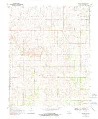
1969 Map of Dacoma SW
USGS Topo · Published 1991About this map
Highland Cem sits on an elevated ridge in this rural Oklahoma landscape, serving as a quiet anchor for the local history of Woods County during the late 1960s. The terrain is organized into distinct townships and districts including Hopeton, Belle, Galena, and Green Valley, reflecting the systematic agricultural and energy extraction patterns of the era. The presence of numerous Gas Wells and a prominent Pipeline cutting through the northeast indicate the region's mid-century economic reliance on natural resources. Water management and communications are marked by functional infrastructure like the Gaging Sta near the western border and a Radio Tower, while Sand Creek meanders across the northern reaches of the Belle district.
Find a feature on this map
19 named features on this map. Tap any name to fly to it.
Don’t see what you’re looking for? This feature index may not catch every label — zoom into the map to look around manually.
Map Details
Editions of this 1969 Dacoma SW Map
2 editions found
Other maps of this area

1955 · Woodward
USGS Topo · 1:250,000

1958 · Woodward
USGS Topo · 1:250,000

1969 · Dacoma
USGS Topo · 1:24,000

1969 · Dacoma SW
USGS Topo · 1:24,000

1969 · Glass Mountains NW
USGS Topo · 1:24,000

1969 · Hopeton
USGS Topo · 1:24,000

1969 · Avard
USGS Topo · 1:24,000

1969 · Waynoka East
USGS Topo · 1:24,000

1969 · Glass Mountains NE
USGS Topo · 1:24,000

1969 · Togo
USGS Topo · 1:24,000