
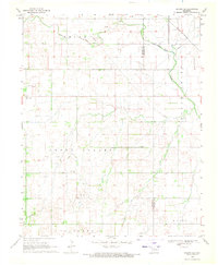
1969 Map of Glass Mountains NE
USGS Topo · Published 1971About this map
The Cimarron River winds through the southern reaches of this landscape, forming a natural boundary between Woods and Major counties. In the late 1960s, the region was defined by a rural grid of townships including Elbert, Oakdale, and Aline, where community life centered around landmarks like Oakdale Ch and the Pleasant Ridge Cem. To the south, the topography rises toward Lone Peak and the drainage of Cheyenne Creek, while the industrial footprint of the Southwest Oakdale Gas Field is evident through numerous Gas Wells and pipelines. The map documents a specific moment in Oklahoma's prairie development, where traditional agricultural land-use patterns began to share the space with energy extraction infrastructure during the mid-century period.
Find a feature on this map
15 named features on this map. Tap any name to fly to it.
Don’t see what you’re looking for? This feature index may not catch every label — zoom into the map to look around manually.
Map Details
Editions of this 1969 Glass Mountains NE Map
This is the sole edition of this map. No revisions or reprints were ever made.
Other maps of this area

1955 · Woodward
USGS Topo · 1:250,000

1958 · Woodward
USGS Topo · 1:250,000

1968 · Carmen
USGS Topo · 1:24,000

1969 · Dacoma SW
USGS Topo · 1:24,000

1969 · Glass Mountains NW
USGS Topo · 1:24,000

1969 · Glass Mountains
USGS Topo · 1:24,000

1969 · Fairview
USGS Topo · 1:24,000

1969 · Cleo Springs
USGS Topo · 1:24,000

1969 · Glass Mountains SW
USGS Topo · 1:24,000
1969 · Dacoma SE
USGS Topo · 1:24,000