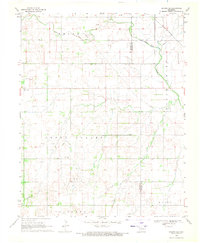
1969 Map of Dacoma SE
USGS Topo · Published 1971About this map
The rolling plains of Woods and Alfalfa counties are defined by a complex network of resource extraction and rural heritage in the late 1960s. Green Valley and Belle represent the expansive agrarian and ranching districts that stretch across this landscape, anchored by community landmarks such as Green Valley Ch and the Good Hope Cem. The infrastructure of the era is clearly visible through numerous Gas Wells and Oil Wells, supported by a diagonal Pipeline that cuts through the survey area. Transport and drainage follow the natural and man-made contours of the land, from the St Louis San Francisco railroad tracks in the northeast to the wandering paths of Eagle Chief Creek and Sand Creek. This map captures the integration of petroleum production into the established rural fabric of north-central Oklahoma.
Find a feature on this map
14 named features on this map. Tap any name to fly to it.
Don’t see what you’re looking for? This feature index may not catch every label — zoom into the map to look around manually.
Map Details
Editions of this 1969 Dacoma SE Map
This is the sole edition of this map. No revisions or reprints were ever made.
Other maps of this area

1955 · Woodward
USGS Topo · 1:250,000

1958 · Woodward
USGS Topo · 1:250,000

1968 · Carmen
USGS Topo · 1:24,000

1969 · Dacoma
USGS Topo · 1:24,000

1969 · Lambert
USGS Topo · 1:24,000

1969 · Dacoma SW
USGS Topo · 1:24,000

1969 · Glass Mountains NW
USGS Topo · 1:24,000

1969 · Hopeton
USGS Topo · 1:24,000

1969 · Cleo Springs
USGS Topo · 1:24,000

1969 · Glass Mountains NE
USGS Topo · 1:24,000