
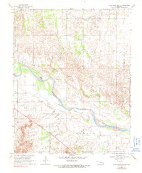
1969 Map of Glass Mountains NW
USGS Topo · Published 1971About this map
The Cimarron River winds through the northwestern reaches of the Glass Mountains, carving a wide valley that serves as the boundary between Woods and Major Counties. This 1969 survey captures the rural character of the region, where the Indefinite Boundary of the river's path shifts against the surrounding plains. The small settlement of Galena is a focal point for local history, centered near the Galena Cem and the natural heights of the Galena terrain.
Find a feature on this map
14 named features on this map. Tap any name to fly to it.
Don’t see what you’re looking for? This feature index may not catch every label — zoom into the map to look around manually.
Map Details
Editions of this 1969 Glass Mountains NW Map
2 editions found
Other maps of this area

1955 · Woodward
USGS Topo · 1:250,000

1958 · Woodward
USGS Topo · 1:250,000

1969 · Phroso
USGS Topo · 1:24,000

1969 · Dacoma SW
USGS Topo · 1:24,000

1969 · Glass Mountains
USGS Topo · 1:24,000

1969 · Waynoka East
USGS Topo · 1:24,000

1969 · Glass Mountains NE
USGS Topo · 1:24,000

1969 · Togo
USGS Topo · 1:24,000

1969 · Glass Mountains SW
USGS Topo · 1:24,000
1969 · Dacoma SE
USGS Topo · 1:24,000