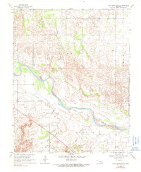
1969 Map of Glass Mountains NW
USGS Topo · Published 1991About this map
The Cimarron River carves a wide, shifting path across this landscape, defining the Indefinite Boundary between Woods and Major Counties. The terrain is characterized by the distinct formations of the Glass Mountains, where early energy exploration is evident through numerous Gas Wells and scattered Drill Holes. Settlement is concentrated near Galena, a community served by the nearby Galena Cem. Local drainage is managed by small tributaries like Barney Creek, which feeds into the larger river valley. The map reveals a transition between the elevated plateaus and the sandy riverbed, documenting the rural infrastructure of the late 1960s, including a Radio Tower and a lonely Grave located in the eastern portion of Liberty.
Find a feature on this map
16 named features on this map. Tap any name to fly to it.
Don’t see what you’re looking for? This feature index may not catch every label — zoom into the map to look around manually.
Map Details
Editions of this 1969 Glass Mountains NW Map
2 editions found
Other maps of this area

1955 · Woodward
USGS Topo · 1:250,000

1958 · Woodward
USGS Topo · 1:250,000

1969 · Phroso
USGS Topo · 1:24,000

1969 · Dacoma SW
USGS Topo · 1:24,000

1969 · Glass Mountains NW
USGS Topo · 1:24,000

1969 · Glass Mountains
USGS Topo · 1:24,000

1969 · Waynoka East
USGS Topo · 1:24,000

1969 · Glass Mountains NE
USGS Topo · 1:24,000

1969 · Togo
USGS Topo · 1:24,000

1969 · Glass Mountains SW
USGS Topo · 1:24,000