
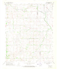
1969 Map of Cleo Springs
USGS Topo · Published 1971About this map
Cleo Springs serves as the focal point of this 1969 Oklahoma landscape, where the confluence of rail, river, and agriculture defines the community's layout. The Atchison Topeka and Santa Fe railroad runs north-south through the terrain, paralleling the winding course of Eagle Chief Creek before it meets the Cimarron River in the southwestern corner. This era of land use is characterized by a significant oil and gas presence, with numerous Oil Wells and Gas Wells dotting the landscape, particularly in the Southeast Chaney Dell Field and the areas surrounding the town site.
Find a feature on this map
18 named features on this map. Tap any name to fly to it.
Don’t see what you’re looking for? This feature index may not catch every label — zoom into the map to look around manually.
Map Details
Editions of this 1969 Cleo Springs Map
This is the sole edition of this map. No revisions or reprints were ever made.
Other maps of this area

1955 · Woodward
USGS Topo · 1:250,000

1958 · Woodward
USGS Topo · 1:250,000

1968 · Carmen
USGS Topo · 1:24,000

1969 · Fairview NE
USGS Topo · 1:24,000

1969 · Helena
USGS Topo · 1:24,000

1969 · Glass Mountains
USGS Topo · 1:24,000

1969 · Fairview SE
USGS Topo · 1:24,000

1969 · Fairview
USGS Topo · 1:24,000

1969 · Glass Mountains NE
USGS Topo · 1:24,000
1969 · Dacoma SE
USGS Topo · 1:24,000