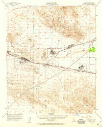
1956 Map of Daggett
USGS Topo · Published 1959About this map
Calico and the surrounding mining district dominate the northern landscape of this mid-century survey, where the Silver Bow Mine and Burcham Mine sit among the peaks. The settlement pattern follows the Mojave River corridor, a critical transit artery defined by the parallel tracks of the Union Pacific and the Atchison Topeka and Santa Fe railroads. Between the river and the northern mountains, several former communities are identified, including the Bismarck and Marian sites.
Find a feature on this map
38 named features on this map. Tap any name to fly to it.
Don’t see what you’re looking for? This feature index may not catch every label — zoom into the map to look around manually.
Map Details
Editions of this 1956 Daggett Map
4 editions found

Other maps of this area

1915 · Searles Lake
USGS Topo · 1:250,000

1932 · Barstow
USGS Topo · 1:125,000

1933 · Avawatz Mountains
USGS Topo · 1:250,000

1934 · Barstow
USGS Topo · 1:125,000

1947 · Trona
USGS Topo · 1:250,000

1948 · Trona
USGS Topo · 1:250,000

1948 · Alvord Mountain
USGS Topo · 1:62,500

1948 · Lane Mountain
USGS Topo · 1:62,500

1951 · Alvord Mountain
USGS Topo · 1:62,500

1951 · Lane Mountain
USGS Topo · 1:62,500