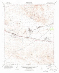
1956 Map of Daggett
USGS Topo · Published 1978About this map
Calico and the surrounding Calico Mountains dominate the northern landscape of this mid-century survey, revealing a region defined by mineral extraction and desert infrastructure. The map documents numerous mining operations including the Burcham Mine, Silver Bow Miner, and St Louis Mine, many accessed via Wall Street Canyon and Odessa Canyon. The transition from industrial mining to modern military logistics is evident in the sprawling installations of the Marine Corps Supply Center (Yermo Area) and its counterparts at Nebo and Daggett.
Find a feature on this map
44 named features on this map. Tap any name to fly to it.
Don’t see what you’re looking for? This feature index may not catch every label — zoom into the map to look around manually.
Map Details
Editions of this 1956 Daggett Map
4 editions found

Other maps of this area

1915 · Searles Lake
USGS Topo · 1:250,000

1932 · Barstow
USGS Topo · 1:125,000

1933 · Avawatz Mountains
USGS Topo · 1:250,000

1934 · Barstow
USGS Topo · 1:125,000

1947 · Trona
USGS Topo · 1:250,000

1948 · Trona
USGS Topo · 1:250,000

1948 · Alvord Mountain
USGS Topo · 1:62,500

1948 · Lane Mountain
USGS Topo · 1:62,500

1951 · Alvord Mountain
USGS Topo · 1:62,500

1951 · Lane Mountain
USGS Topo · 1:62,500