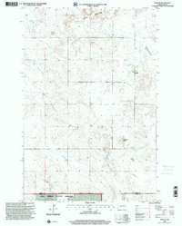
1997 Map of Daglum
USGS Topo · Published 2001About this map
Little Missouri National Grassland dominates this portion of the western North Dakota plains, where the small settlement of Daglum serves as a local focal point near the border of Stark and Slope Counties. The landscape is defined by the stark erosion of the Little Badlands in the north and the prominent elevation of Flagstaff Butte to the south. This late-twentieth-century revision by the Forest Service highlights a rural community anchored by the Daglum Church and its adjacent Cemetery. Water management is central to the area's geography, visible through the course of Antelope Creek and the presence of Fisher Dam, reflecting the requirements of ranching and agriculture in a semi-arid environment. A Gravel Pit near the county line indicates the localized extractive industry supporting the area's road network.
Find a feature on this map
10 named features on this map. Tap any name to fly to it.
Don’t see what you’re looking for? This feature index may not catch every label — zoom into the map to look around manually.
Map Details
Editions of this 1997 Daglum Map
This is the sole edition of this map. No revisions or reprints were ever made.
Other maps of this area

1953 · Dickinson
USGS Topo · 1:250,000

1957 · Dickinson
USGS Topo · 1:250,000

1961 · Daglum
USGS Topo · 1:62,500

1962 · Belfield SW
USGS Topo · 1:24,000

1962 · Belfield SE
USGS Topo · 1:24,000

1973 · New England NW
USGS Topo · 1:24,000

1973 · New England SW
USGS Topo · 1:24,000
1973 · South Heart
USGS Topo · 1:24,000

1980 · Belfield
USGS Topo · 1:100,000
1981 · Dickinson
USGS Topo · 1:100,000