
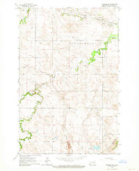
1962 Map of Belfield SE
USGS Topo · Published 1964About this map
The Little Badlands define the southern landscape of this Stark County region, where intricate topography meets the winding course of the Heart River. Surveyed in the early 1960s, the map illustrates a rural environment shaped by drainage patterns and early industry. The Burlington Northern railroad cuts through the northern sections, following the river valley through a series of dramatic bends. This corridor was essential for moving goods through the northern plains, supported by local extraction as evidenced by a labeled Mine located north of the river. Tributaries like Norwegian Creek and the South Branch Heart River reach deep into the uplands, while the Bull Creek drainage highlights the erosional character of the land. A notable engineering detail includes a Spillway Elev 2670, reflecting water management efforts in this semi-arid North Dakota terrain during the mid-century era.
Find a feature on this map
10 named features on this map. Tap any name to fly to it.
Don’t see what you’re looking for? This feature index may not catch every label — zoom into the map to look around manually.
Map Details
Editions of this 1962 Belfield SE Map
2 editions found
Other maps of this area

1953 · Dickinson
USGS Topo · 1:250,000

1957 · Dickinson
USGS Topo · 1:250,000

1961 · Daglum
USGS Topo · 1:62,500

1962 · Belfield NE
USGS Topo · 1:24,000

1962 · Belfield SW
USGS Topo · 1:24,000

1962 · Belfield
USGS Topo · 1:24,000

1973 · New Hradec South
USGS Topo · 1:24,000

1973 · New England NW
USGS Topo · 1:24,000
1973 · South Heart
USGS Topo · 1:24,000

1980 · Belfield
USGS Topo · 1:100,000