
1962 Map of Belfield NE
USGS Topo · Published 1964About this map
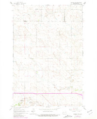
Zenith anchors the southwestern corner of this West Dakotan landscape, situated along the tracks of the Northern Pacific railroad. The territory is defined by the convergence of the Green River, North Creek, and the Heart River, which carve drainage patterns through the high plains. This 1962 survey reveals a land defined by extraction and early education, where Green River Sch No 4 served remote homesteads and several localized coal or gravel operations, such as Walters Mine and Karsky Mine, dotted the draws. Of particular note are the numerous Scoria Pits and Strip Mines near the rail line, indicating the region's industrial reliance on its geology. At the time of this survey, a major highway expansion was marked as Proposed, signaling the transition toward modern interstate transport that would eventually reshape the local economy.
Find a feature on this map
17 named features on this map. Tap any name to fly to it.
Don’t see what you’re looking for? This feature index may not catch every label — zoom into the map to look around manually.
Map Details
Editions of this 1962 Belfield NE Map
2 editions found
Other maps of this area

1953 · Dickinson
USGS Topo · 1:250,000

1953 · Watford City
USGS Topo · 1:250,000

1957 · Dickinson
USGS Topo · 1:250,000

1957 · Watford City
USGS Topo · 1:250,000

1962 · Belfield SW
USGS Topo · 1:24,000

1962 · Belfield
USGS Topo · 1:24,000

1962 · Belfield SE
USGS Topo · 1:24,000

1963 · Fairfield SE
USGS Topo · 1:24,000

1963 · Rattlesnake Butte
USGS Topo · 1:24,000

1967 · Watford City
USGS Topo · 1:250,000