
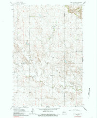
1963 Map of Fairfield SE
USGS Topo · Published 1964About this map
The Green River and its South Fork carve a dendritic drainage pattern across this western North Dakota landscape on the border of Billings and Dunn counties. The map documents a rural cultural landscape defined by its ethnic heritage and dispersed settlement, visible through landmarks like the Ukrania School and St Demetrius Cemetery. These names reflect the specific settler history of the region in the early 1960s. Educational and spiritual life is anchored by several small country schools, including the Hecker, Barta, and Willmen schools, and the SS Peter and Paul Cemetery. The terrain is further marked by ephemeral waterways like Horse, Indian, and Spring creeks, which navigate the high prairie breaks. Aside from a single Gravel Pit, the area remains focused on agricultural land use, with numerous field and fence lines meticulously noted across the sections.
Find a feature on this map
13 named features on this map. Tap any name to fly to it.
Don’t see what you’re looking for? This feature index may not catch every label — zoom into the map to look around manually.
Map Details
Editions of this 1963 Fairfield SE Map
2 editions found
Other maps of this area

1953 · Dickinson
USGS Topo · 1:250,000

1953 · Watford City
USGS Topo · 1:250,000

1957 · Dickinson
USGS Topo · 1:250,000

1957 · Watford City
USGS Topo · 1:250,000

1962 · Belfield NE
USGS Topo · 1:24,000

1962 · Belfield
USGS Topo · 1:24,000

1963 · Fairfield
USGS Topo · 1:24,000

1963 · Rattlesnake Butte
USGS Topo · 1:24,000

1963 · Hungry Man Butte
USGS Topo · 1:24,000

1967 · Watford City
USGS Topo · 1:250,000